地籍管理考试双语资料Word文档下载推荐.docx
《地籍管理考试双语资料Word文档下载推荐.docx》由会员分享,可在线阅读,更多相关《地籍管理考试双语资料Word文档下载推荐.docx(23页珍藏版)》请在冰豆网上搜索。
location,quality,etc.
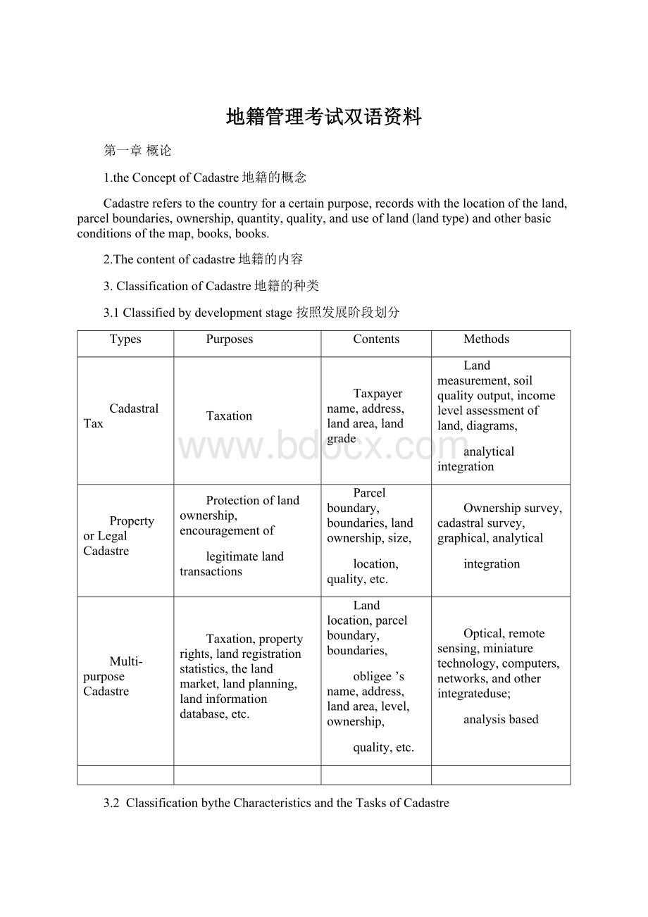
Ownershipsurvey,cadastralsurvey,graphical,analytical
integration
Multi-purposeCadastre
Taxation,propertyrights,landregistrationstatistics,thelandmarket,landplanning,landinformationdatabase,etc.
Landlocation,parcelboundary,boundaries,
obligee’sname,address,landarea,level,ownership,
quality,etc.
Optical,remotesensing,miniaturetechnology,computers,networks,andotherintegrateduse;
analysisbased
3.2ClassificationbytheCharacteristicsandtheTasksofCadastre
Definitions
Functions
InitialCadastreSurvey
Inacertainperiod,fulladministrativearealandsurveysfortheadministrativeregionsabovethecountylevel,andtheinitialcadastralmaps,books.
Thebasisforcadastralmanagement,landvaluation,landuseplanning
ChangedCadastralSurvey
Forlandquantity,quality,ownership,distribution,usageandotherchanges,andtotheinitialcadastralamendment,supplementandupdate
MaintainthecurrentmomentumandcontinuityofCadastralinformation
3.3Classificationbythelevelofadministrativemanagement
Objects
NationalCadastre
LandsforcollectivelandownershipunitsandfirstlanduserightsUnitsforstate-ownedland,etc.ruralhousinglandsandtownshipandvillageenterpriseslands,
主要服务于土地权属的国家统一管理Mainlyservedforthenationallandtenureoftheunifiedmanagement
基层地籍PrimaryCadastre
集体土地使用者的土地和国有土地的二级使用者的土地Collectivelandandstatelandforthesecondaryusers
主要服务于土地利用或使用的指导和监督Mainlyservedforthelanduse'
sguidanceandsupervision
3.4Classificationbythedifferentcharacteristicsoftheurbanandrurallands
Requirements
UrbanLands
城市,镇城区用地,独立工矿用地,交通用地
City,town'
surbanland,anindependentminingland,trafficland
高精度,高技术含量,大比例尺,使用城镇地籍规范Highprecision,hightechnicalcontents,largescale,usecitiescadastralnorms
RuralLands
Theoutskirtsoftown,ruralcollectiveownershipland,ruralresidentsland,thestate-ownedfarmland城镇郊区,农村集体所有制土地,农村居民地,国营农场的国有土地
Slightlydowngradedrequirements,useruralcadastralnorms略降级要求,使用农村地籍规范
2.CadastralManagementtasks地籍管理的任务
Cadastremanagementtasksincludingcollection,records,storage,updateandproviderelevantnatural,economic,social,legalaspectsoflandinformationsforscientificmanagementoflandservices地籍管理的任务包括收集、记载、保管、更新并提供有关土地的自然、经济、社会、法律等方面的信息,为科学管理土地服务。
3.theprincipleofcadastralmanagement地籍管理的原则
*Ensurecadastralmaterialunityandstandardization
*Ensurecadastralinformationsystemandcontinuity
*Ensurecadastralmaterialreliabilityandaccuracy
*Ensurecadastralinformationintegrityandhistorically
*Ensurecadastralmaterialthemulti-purposeandhighefficiency
4.Thecontentsystemofcadastralmanagement
5.Cadastremanagementmeansandmethods地籍管理的方法
Administrationtechnologyeconomylaw
第二章LandUseStatusInvestigation土地利用现状调查
SectionILandUserStatusInvestigationoverview
Theconcept,purposeoflandutilizationstatusinvestigation土地利用现状调查的概念和意义
1、Concept
LandUseStatusInvestigationreferstointhecountry,surveyedbythecounty,spotasthebasicunit,accordingtothecurrentlanduseclassification,foundoutofvarioustypesoflandarea,distribution,utilizationandownershipstatus,alsocalledlandquantitysurvey.
1.1Thetypesforlandusestatusinvestigation
Initialinvestigation
Updatesurvey
SurveyChanged
1.2ThepurposesoflanduseStatusinvestigation利用现状调查的目的
1)Servicedforformulatingnationaleconomicplanandrelevantpolicy;
2)Providedthescientificbasisforagriculturalproductionandruralconstruction;
3)Servicedforestablishingthelandregistration,landstatisticssystem;
4)Providingbasicdataforlandusedynamicmonitoring;
5)Servicedformakinggenerallanduseplanningandtheoveralllandmanagement.
1.3theprincipleoflandusestatusinvestigation利用现状调查的原则
&
Theprincipleofseekingtruthfromfacts
Theprincipleofoverall,scientificinvestigation
Theprincipleofonesurveyformulti-purpose
1.4Contentsandachievementoflandusestatusinvestigation土地利用现状调查的内容和成就
1.Contents内容
1)Ascertaininglandownershipboundariesandvariousadministrativejurisdictionboundaries;
2)Measuringlandusetypesandcalculatingvariouslandareas;
3)Calculatinglandownershipunitsandadministrativeregion,andcollectingatotallandareaandeachlandtypes'
area
2.Themajorachievements
外业调查手簿Fieldsurveyhand-book
土地权属界线图landownershipboundarymap县、乡两级土地利用现状图landusestatuschartforcountyandtownshiplevels各类土地统计表格Allkindsoflandstatisticsforms土地利用现状调查报告Landusestatussurveyreports
其他归档资料Otherarchiveddata
土地利用现状标准分幅图Landusestandarddivisionmap
土地调查报告Landinvestigationbook
土地统计台账Landaccountingbook
SectionIILandClassificationSystem土地分类系统
1.土地分类的目的是为了正确认识土地,从而能因地制宜地开展土地开发、利用、保护、改良、调查、统计和管理等。
Thepurposeoflandclassificationistobegetcorrectunderstandingofland,andthatcanbeadjustedmeasurestolocalconditionstohelpthelanddevelopment,utilization,protection,improvement,investigation,statisticsandmanagementetc.
2.土地分类研究对象的核心是分类标志,分类标志依据土地分类成果应用的需要而不同。
Thecoreresearchobjectoflandclassificationistaxonomy,accordingtodifferentapplications,thelandclassificationresultswouldbemarked.
3.土地分类:
按一定分类标志(指标),将性质上有差异的土地划分为若干类型。
Landclassification:
accordingtocertainclassificationmark(index),differentkindsofthelandwillbedividedintoseveraltypes.
4.土地分类系统:
按照统一规定的原则和分类标志,将分类的土地有规律分层次地排列组合在一起,叫土地分类系统(或土地分类体系)。
Landclassificationsystem:
accordingtotheprincipleofunifiedregulationandmarking,theclassificationsoflandwillbepermutatedandcombinedregularlytogether,sothatthelandclassificationsystemshouldbeget.
5.我国在科学研究和实际工作中常见的土地分类系统有:
1)、土地自然分类系统LCSbynaturalfeatures
2)、土地评价分类系统LandevaluationclassificationSystem
3)、土地利用分类系统LanduseclassificationSystem
我国自建国采用了四种分类
1、土地利用现状分类LandUseStatusClassification
2、城镇土地分类UrbanlandClassification
3、全国土地分类(试行)Thenationallandclassification(Trial)
4、全国土地分类(过渡期间适用)Thenationallandclassification(Transitionperiodapplicableversion)1.土地利用现状分类(LandUseStatusClassification)
1984年全国农业区划委员会制定的《土地利用现状调查技术规程》采用两级分类:
8个一级类、46个二级类。
2.城镇土地分类(UrbanLandClassification)
1989年原国家土地管理局制定的《城镇地籍调查技术规程》,对城、镇、村土地分类做了细化和充实,也采用两级分类:
10个一级类、24个二级类。
3.全国土地分类(试行)(Thenationallandclassification(trial)))
2001年国土资源部颁布的《全国土地分类(试行)》,在以上两个土地分类的基础上,采用三级分类:
3个一级类,15个二级类、71个三级类。
4.全国土地分类(过渡期间适用)Thenationallandclassification(transitionperiodapplicable)
2002年国土资源部颁布的《全国土地分类(试行)》,在过渡时期使用,采用三级分类:
3个一级类,10个二级类、52个三级类。
TheNationalLandClassification(Trail)waspromulgatedbytheMinistryofLandandResourcesin2002,hadbeusedinthetransitionperiod,withinthelevel3classifications:
3level1classes,10level2classes,52level3classes.
1984年的分类
1.耕地Cultivatedland
11、灌溉水田Irrigatedpaddyfields
12、望天田Rainfedpaddyfields
13、水浇地Irrigatedland
14、旱地Dryland
15、菜地Vegetableplots
2.园地Gardenplots
21、果园Orchards
22、桑园Mulberryfields
23、茶园Teaplantations
24、橡胶园Rubberplantations
25、其他园地Other
3.林地Forestland
31、有林地Woodland
32、灌木林地Shrubberylands
33、疏林地Sparselyforestedwoodland
34、未成林造林地Afforestationland
35、迹地Slashes
36、苗圃Seedlingnurseries
4.牧草地PastureLand
41、天然草地Naturalgrassland
42、改良草地Improvedgrassland
43、人工草地Man-madegrassland
5.居民点及工矿用地Residentialquartersandindustrialandminingland
51、城镇Areasofcitiesandtown
52、农村居民点Residentialquartersinruralareas
53、独立工矿用地Isolatedindustrialandminingland
54、盐田Saltpans
55、特殊用地Specially-usedland
6.交通用地Landsusedfortransportation
61、铁路Railways
62、公路Highways
63、农村道路Ruralroads
64、民用机场Civilairports
65、港口、码头Harborsandwharfs
7.水域Waterarea
71、河流水面Riversurface
72、湖泊水面Lakesurface
73、水库水面Reservoirsurface
74、坑塘水面Pondsurface
75、苇地Reedland
76、滩涂Beachesandflats
77、沟渠Irrigationcanalsandditches
78、水工建筑物GlaciersandfirnsHydraulicconstructionland
79、冰川及永久积雪Glaciersandpermanentsnowlands
8.未利用土地Unusedlands
81、荒草地Wastedland
82、盐碱地Saline-alkaliland
83、沼泽地WetLand
84、沙地Sandyland
85、裸土地Bareland
86、裸岩、石砾地Exposedrockandshingleland
87、田坎Ridges
88、其它Other
1989年城镇土地分类(1989)10个一级类、24个二级类
10.商业金融业用地Commercialbankingsites11、商业服务业commercialservices
12、旅游业tourism13、金融保险业financialinsurance
20.工业仓储用地Industrialstoragesites21、工业industrial
22、仓储storage30.市政用地Municipalland
31、市政公用设施municipalutilities32、绿化green
40.公共建筑用地Publicbuildinglands41、文、体、娱Culture,P.E,entertainment
42、机关、宣传organs,propaganda43、科研、设计scientificand
44、教育education45、医卫medicalhealth
50.住宅用地住宅Housinglandhousing60.交通用地Thelandfortraffic
61、铁路railway62、民用机场civilairport
63、港口、码头ports,docks64、其他交通othertraffic
70.特殊用地Specialland71、军事设施militaryfacilities
72、涉外foreign73、宗教religious
74、监狱prisons80.水域用地Watersland
90.农用地Agriculturalland91、水田paddyfields
92、菜地vegetablefield93
 升级会员
升级会员 