Geophysical Science Finals Review Part 22.docx
《Geophysical Science Finals Review Part 22.docx》由会员分享,可在线阅读,更多相关《Geophysical Science Finals Review Part 22.docx(19页珍藏版)》请在冰豆网上搜索。
GeophysicalScienceFinalsReviewPart22
Hydrogeology
TheHydrologicCycle
∙HydrologicCycle:
aconceptualmodelthatdescribesthestorageandmovementofwaterbetweenEarth’sdifferentspheres.
∙Reservoir:
locationwherewateronEarthcanbestoredsuchasatmosphere,oceans,lakes,rivers,soils,glaciers,snowfields,andgroundwater
-Watermovesbetweeneachreservoirthroughprocessesofevaporation,condensation(clouds),precipitation,deposition,runoff,infiltration(goesthroughsoil),sublimation(fromsolidtogas,occursnearsnow-coveredmountainpeaksetc.),evapotranspiration(plantsbreathing),melting,andgroundwaterflow.
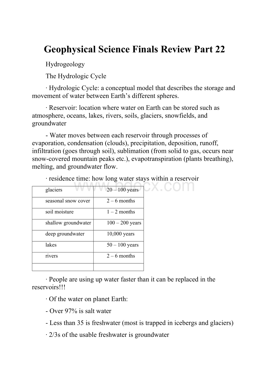
∙residencetime:
howlongwaterstayswithinareservoir
glaciers
20–100years
seasonalsnowcover
2–6months
soilmoisture
1–2months
shallowgroundwater
100–200years
deepgroundwater
10,000years
lakes
50–100years
rivers
2–6months
∙Peopleareusingupwaterfasterthanitcanbereplacedinthereservoirs!
!
!
∙OfthewateronplanetEarth:
-Over97%issaltwater
-Lessthan35isfreshwater(mostistrappedinicebergsandglaciers)
∙2/3softheusablefreshwaterisgroundwater
∙Sunlightisthepowerengineofthewatercycle
∙Precipitationcan…
-Returntooceansasrunoff
-Seepintogroundwater
-Returntotheair
-Gothroughplantsthenbackintotheair
∙Porosity:
percentageofamaterial’svolumethatisporespace,howmuchwatercanbeheld
-Variesbecauseofparticleshapeandsorting
-Roundandwellsorted=highporosity
∙Permeability:
ratewaterorotherliquidspassthroughporespacesofarock
-Increaseswithgrainsize
-Ifamaterialisimpermeable,watercannotpassthroughit
∙capillarywater:
waterthatstickstoparticlesasitpassesthrough,canbereturnedtowatercyclebyevapotranspiration
∙Watertablevariesbecauseof…
-rainfall
-season
-groundslope
-climate
-rainfrequency
-soilthickness
∙watertablelocations:
-swamp,lakes,rivers,surface
-deserts,hundredofmetersbelowsurface
-farmland,fields,andwoods,fewmetersbeneathsurface
∙hardwateriswaterwithhighmineralcontent(wellsareharderthanrivers)
∙buildersinCantonusepeagravelandathickclaylayerinhomeconstructionbecausepeagravelispermeableandensureswallwontcrackinthecaseofflooding
Vocabulary(suggested)
∙zoneofsaturation:
allporespacesfilled
∙zoneofaeration:
sectionbetweenwatertableandsurfacethatcanstillholdsomewater
∙watertable:
uppersurfaceofthezoneofsaturation
∙capillaryaction:
interactionbetweenwaterandsoilthatallowswatertomoveagainstgravity
∙capillaryfringe:
wherecapillaryactionoccurs
∙ordinarywell:
wellcontainingwateruptothelevelofthewatertable
∙naturalspring:
areawherewatertablemeetsgroundsurface
∙aquifer:
permeablelayersofrockandsedimentthatstoreenoughwatertosupplyawell
∙artesianformation:
sandwichofpermeablelayerthatistrappedbetweentoimpermeablelayers
-caprock:
toplayerofimpermeablerockinanartesianformation
-artesianspring:
formswhentherearefissuresinanartesianformation
∙mineraldeposits:
highconcentrationofminerals
∙mudpot:
weatheredrockaroundahotspringthatmakesthewaterformaliquidclay,bubblingatthesurface
∙geyser:
hotspringthatintermittentlyshootscolumnsofhotwaterandsteam
∙mineralspring:
springscontainingaspecificamountofmineral
∙cavern:
largerundergroundchamber
∙sinkhole:
circulardepressioncausedwhentheroofofacaverncollapses
∙Karsttopography:
nameappliedtoahillylandscapewithnumerousdepressions
∙Stalactites:
cone-shapedcalcitedepositsuspendedfromtheceilingofacavern
∙Stalagmite:
con-shapedcalciumdepositthatpointsupwardsandisbuiltupfromacavernfloor
∙waterbudget:
describestheincomeandspendingofwaterforaregion
-surplus:
whenthereismoreprecipitationthanevaporation
-deficit:
whenthereismoreevaporationthanprecipitation
-humansareusinggroundwaterfasterthannaturecanrestockit
-pollutionisthreateningthesafetyofgroundwaterbecausepollutedsurfacewaterisseepingintogroundwater
-pollutingagentsinclude:
pesticide,oil,fertilizer,sewage,salt
-toomanyimpermeablesurfacespreventwaterfrombeingstored
SurfaceWater
∙runningwaterisaveryeffectiveagentoferosion
-erodesbyabrasion(roundingrock)
∙runningwatercanremoveerodedmaterialin3ways:
-solution:
veryfine,25%,notvisible
-suspension:
muddy,50%,givesriversitscolor
-bedload:
heavyrocksandboulders,25%,atbottomofrivers
∙carryingpower:
abilitytocarrymaterial
-dependsonthespeedofwaterandthedischarge(volumeofwater)
ErosionandWaterfalls
ThreeStagesofRivers
∙Young:
V-shapedvalley
-Fastflowing
-Steepsides
-Runsstraight
∙Mature:
reducedslopes
-Widersidesandwiderfloodplain
-Flowsslower
-Beginstomeander
∙OldAge:
gentleslope
-Verywidesides
-Slowflowing
-Oxbowlakes
-Withcut-offs
-Leveesformed
∙Riversstartwithgullies
∙Awatershedordrainagebasinistheriver,itstributaries,andallthelanditdrainsinto
FloodsandRiversContinued
∙Afloodoccurswhenariveroverflowsitsbanks,2thingshappenduringaflood
-Thespeedoftheriverflows
-Sedimentloadisimmediatelydeposited(theyformridgescalledlevees)
∙Floodplain:
veryfertilesoil,duetonutrientsfromoverflowedwater
∙ReasonsforFlooding:
heavy,longperiodsofrain,meltingofsnowonfrozenground,flashflood,damfailures
∙Floodpreventiontechniques:
-deepvegetationofbanksofrivers
-builddamsupstream
-buildleveestokeepwaterinsidebanks
-buildspillways(parallelchannelsforwatertoflowintoduringaflood)
∙depositionoccursinsidebanks
∙erosionoccursoutsidebanks
∙themosteffectiveerosiveagentiswater,itbreaksupbedrockandremovesweatheredanderodedmaterials
∙Watercanchemicallydissolvesolublematerial,andwidencracksandholes
∙Thespeedofastreamisdeterminedbysteepnessanddischarge
∙Riversystem:
ariverandallitstributaries
∙windgap:
abandonedwatergap
∙watergap:
narrowcutinridgethroughriver
∙Thefactorsthatcauseadecreasein:
-Speed:
slopedecreases,bankwidens,obstruction,emptyingintosea
-Discharge:
aridregion,seepage
∙Delta:
fanshapeddepositatmouthofriver,formswhenriverflowsintoquietbodyofwater
∙alluvialfan:
sedimentwashdownonmountainside,formwhenamountainstreammeetslevelland
∙levee:
build-updepositalongastream
OceansandElNiño
PropertiesoftheOcean
∙70%ofEarth’ssurfaceiswater,hencethename,“TheWaterPlanet”
∙Thereare4majoroceansrankedlargesttosmallest
−Pacific
−Atlantic
−Indian
−Arctic
∙Averagedepthofoceansis4x>averageelevation
WorldWar2
∙Helpedmakeadvancesinoceanicresearchwhilelookingforenemysubmarinesandmines
Salinity
∙Measurementofdissolvedions(mostlysodiumchloride)
∙Averageof35partsper1,000ml(3.5%)
TemperatureZonesintheOcean
∙3differenttemperaturezones
−MixedLayer:
haswind,waves,sunlight,andbeautifulaquaticlife
−Thermocline:
rapidtemperaturedeclineoccursinthislayer
−Deep:
verydeep,dark,andcold
∙2majorsourcesofoxygenintheocean
−Airmixedinfromsurfacewaves
−Airgivenofbyplantlifeintheocean
∙Oxygen,sunlight,andtemperaturedecreaseasdepthincreases
∙CO2increasesasdepthincreases
∙3thingsthatcausesalinitytodecreaseby3.4%
−Largeamountsoffreshwaterex)MississippiRiver
−Heavyrainfallatequator
−Polarwaterswhereglaciersarelocated
∙Regionswithaboveaveragesalinityby3.6%
−Hot,dry.Climates
−Polarwaters
∙Scientistsmeasuresalinitywithelectricalconductivity(saltwaterallowselectricalcurrentstopassthrough,therefore;waterswithhighersaltcontentwillallowanelectricalcurrenttopassfaster)
∙Saltwatercontainsvaluableelements(ions)besidessaltsuchascopper,gold,anduraniumintraceamounts
MEMORIZEATTACHEDDIAGRAM!
Note:
notalltermsavailable,studywrittennotes
OceanCurrents(anycontinuousflowofwateralongabroadpathintheocean,atthesurfaceorbellow)
∙Surfacecurrents:
−MoveclockwiseinN.hemisphere
−Movecounter-clockwiseinS.hemisphere
−Flowinupper1000metersofocean
∙Surfacecurrentsaredrivenbywind:
−Tradewinds:
akaeasterlies,blownearequatorfromtheeast
−Westerlies:
blowtoPolarRegionsfromthewest
∙Typesofsurfacecurrents:
−Warmcurrents:
onwestsideofoceanandblowawayfromequator(towardspolarregions)
−Coldcurrents:
oneastsideonoceanandblowtowardsequator(awayfrompolarregions)
−Countercurrents:
flowinoppositedirectionofsurfacecurrents,usuallyfoundalongequator,isapartoftheglobalconveyorbeltakathermohalinesystemthatcirculateswateraroundtheglobe
∙DensityCurrents:
cold,densewaterthatsinksfromsurfacetooceanbottomex)turbiditycurrents,theymoveslowercomparedtosurfacecurrents
Whysinwhichdensitycanchangeare:
1.Salinityincreases,densityincreases
2.
Evaporationincreases,densityincreases
3.Freezingincreases,densityincreases
4.Temperaturedecreases,densityincreases,
5.Polaranddesertregionsalsocontaindensewater
Upwelling:
coldwaterbroughttothesurfacethatbringsnutrientsforphytoplankton;itoccursonwestsideofcontinentsandisgoodforfishingindustries
ElNiño
∙PhenomenonthatoccurswhenseasurfacetemperatureintheeasternequatorialPacificbyPeruismuchwarmerthannormal.Tradewindsweakeninthissituationthenreversealongtheequator.
 升级会员
升级会员 