Nutrient.docx
《Nutrient.docx》由会员分享,可在线阅读,更多相关《Nutrient.docx(9页珍藏版)》请在冰豆网上搜索。
Nutrient
NUTRIENTTRANSPORTDURINGBIOREMEDIATIONOFCRUDE
OILCONTAMINATEDBEACHES
BrianA.Wrens'(EnvironmentalTechnologies&Solutions,Rochester,NY)
MichelC.BoufadelandMakramT.Suidan(Univ.ofCincinnati,Cincinnati,OH)
AlbertD.Venosa(U.S.EPA,Cincinnati,OH)
ABSTRACT:
Theeffectofwaveenergyontransportofdissolvednutrientsintheintertidalzoneofsandybeacheswasstudiedbycomparingthewashoutratesofaconservativetracer(lithium)ontwobeachesinMaine.Thephysicalcharacteristicsofthetwobeachesweresimilar,andtheyweresubjectedtothesametidalinfluences,butthewaveenergieswereverydifferent.ScarboroughBeachisahighenergybeachthatfacessoutheasttowardtheAtlanticOcean,whereasFerryBeachisinaprotectedharbor.ThisdifferenceinwaveenergycausedlithiumtobewashedoutofScarboroughBeachmuchmorerapidlythanfromFerryBeach.ThehigherwaveenergyatScarboroughBeachalsoappearstohaveincreasedtheamountoflithiumthatwasdiluteddirectlyintothewatercolumn.Thesedifferencesintransportrateandmechanismhaveimportantimplicationsforthefeasibilityofbioremediationforcleanupofoilcontaminatedshorelines.
INTRODUCTION
Thegrowthrateofoildegradingbacteriaoncontaminatedshorelinesisoftenlimitedbytheavailabilityofnutrients,suchasnitrogenandphosphorus(PritchardandCosta,1991;Braggetal.,1993;Leeetal.,1993;Venosaetal.,1996).Effectivebioremediationrequiresnutrientstoremainincontactwiththeoiledbeachmaterial,andtheconcentrationsshouldbesufficienttosupportthemaximalgrowthrateoftheoildegradingbacteriathroughoutthecleanupoperation.Contaminationofcoastalareasbyoilfromoffshorespillsusuallyoccursintheintertidalzone,wherethewashoutofdissolvednutrientscanbeextremelyrapid.Lipophilicandslowreleaseformulationshavebeendevelopedtomaintainnutrientsincontactwiththeoil(AtlasandBartha,1992),butmostoftheserelyondissolutionofthenutrientsintotheaqueousphasebeforetheycanbeusedbyhydrocarbondegraders(Safferman,1991).Therefore,designofeffectiveoilbioremediationstrategiesandnutrientdeliverysystemsrequiresanunderstandingofthetransportofdissolvednutrientsintheintertidalzone.
Transportthroughtheporousmatrixofabeachisdrivenbyacombinationofthreemainfactors:
tide,waves,andtheflowoffreshwaterfromcoastalaquifers.Thefocusofthisresearchwasontheeffectsoftideandwaveactivity.Tidalinfluencescausethegroundwaterelevationinthebeach,aswellastheresultinghydraulicgradients,tofluctuaterapidly(Nielsen,1990;Wrennetal.,1997).Waveactivityaffectsgroundwaterflowthroughtwomainmechanisms.First,whenwavesrunupthebeachfaceaheadofthetide,someofthewaterpercolatesverticallythroughthesandabovethewaterlineandflowshorizontallywhenitreachesthewatertable(RiedlandMachan,1972).Wavescanalsoaffectgroundwatermovementinthesubmergedareasofbeachesbyapumpingmechanismthatisdrivenbydifferencesinheadbetweenwavecrestsandtroughs(Riedletal.1972).
Therelativeeffectsoftideandwavesonnutrienttransportintheintertidalzoneofsandybeacheswasinvestigatedbycomparingthewashoutofaconservativetracer,lithium,ontwobeachesinsouthernMaine.ScarboroughBeachisahighenergybeachthatfacestheAtlanticOcean,whereasFerryBeachisinashelteredharboratthemouthoftheScarboroughMarsh.Lithiumtransportat
FerryBeachwasdrivenalmostexclusivelybytidaleffects,whereastideandwavesbothaffectedtransportatScarboroughBeach.
EXPERIMENTALDESIGN
SiteDescription.Thetwobeachesusedinthisstudyaresubjectedtoverydifferentwaveenergies,butinotherrespectstheyarequitesimilar.Botharecomposedprimarilyofmediumtofinesandwithrelativelynarrowparticlesizedistributions.DifferencesinthecompositionofthetwobeachessuggestthatthehydraulicconductivityofScarboroughBeachmightbeslightlylargerthanFerryBeach,butthesmallpermeabilitydifferenceswereexpectedtohavemuchlessinfluenceonsolutetransportthanthedifferencesinwaveenergy.Thetidewasidenticalatbothsites.
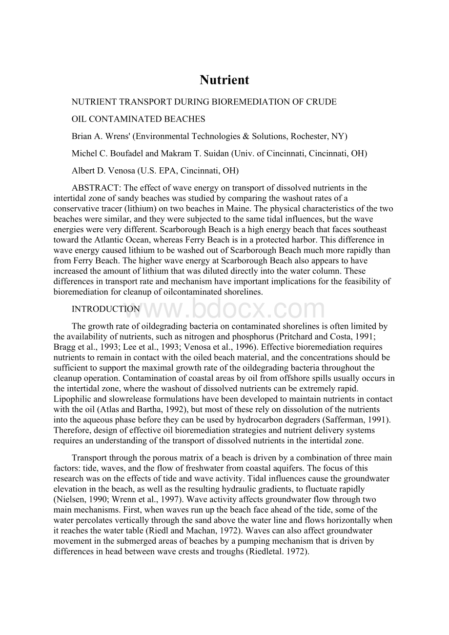
PlotSetupandSampleCollection.Thetracerwasappliedtothebeachindiscreteareascalled"plots."Eachplotwas5mwide(i.e.,paralleltotheshoreline),andtheywereeither10m(FerryBeach)or12m(ScarboroughBeach)long(i.e.,perpendiculartotheshoreline).AlthoughtheplotsonFerryBeachwereshorterthanthoseonScarboroughBeach,thedifferenceinelevationbetweenthetops(i.e.,thelandwardedges)andthebottoms(i.e.,theseawardedges)oftheplotswasapproximatelythesameonbothbeaches.Theplotsweresetupsuchthatthelandwardedgeswereattheelevationthatwasexpectedforthehighesttidethatwouldoccurduringthestudy.
Atransectconsistingofsixmultiportsamplewellswasinstalledperpendiculartotheshorelinethroughthecenterofeachplot.ThelayoutofthesetransectsandtheelevationsofthetopsandbottomsoftheplotsonbothbeachesareshowninFigure1.Threeofthesixsamplewellswereinstalledinsidetheplots,onewellwasinstalledlandwardoftheplots,andtwowereinstalledseawardoftheplots.Figure1alsoshowsthelocationsofthesampleportsforeachwell.
Sprinklerswereusedtoapplythetracertothebeachsurfaceinsidetheplotboundariesatlowtide.Lithiumnitrate(>99.7%;CyprusFooteMineralCo.,KingsMountain,NC)wasdissolvedin100gallonsoffreshwatertoafinalconcentrationof33g/L,whichgaveitadensityapproximatelyequaltothelocalseawater.Watersampleswerecollectedfromthemultiportwellsperiodicallyforabouttwoweeks.
WaterLevelMeasurement.Thewaterlevelsinthebeachesweremeasuredwithtransectsofsixpiezometerwellsthatwereinstalledperpendiculartotheshoreline.Piezometerwellswereinstalledatthetop,bottom,andmiddleoftheplots.Onewellwaslandwardofthetop,andtwowereseawardofthebottomoftheplots.Themostseawardwell,whichwasscreenedoverafourfootintervalabovethebeachsurface,wasusedprimarilytomeasurethelevelofthetidewheneveritwashighenoughtosubmergeanypartofthesamplewelltransects.Vibratingwirepiezometers(RocTest,Inc.,Plattsburgh,NY)wereusedtomeasurethewaterlevelateachwellposition.Threereadingswereusuallytakenforeachpiezometerevery15minutes.Thesethreereadingswereaveragedtosmoothouttheeffectofwavesonthewaterlevelmeasurements.
RESULTSANDDISCUSSION
HydraulicGradients.Thetwomainforcesthatdrivesolutetransportinsandybeachesarewavesandtidallyinducedhydraulicgradients.Althoughnoquantitativemeasurementsofthewaveactivityatthetwobeachesusedinthesestudiesareavailableatthistime,aqualitativecomparisoncanbemadebyinspectionofFigure1.WhereasthewaterlevelchangedfairlysmoothlyatFerryBeachin
1.0
o
y
~3s
L)
n
oo
.'
4)
o
._
4,
2
3
4
:
10
time(days)
0.50.00.5
....
.\beachsurfaceFerryBeach
tidell(lowenergy)tpOIPOt°f
1.0
bottom[\ofplotsI\
+
samplingwells
beach\surface
r~
ScarboroughBeach
(highenergy)
.~.
'~()~~~~,
_,<,<,_
10
topOfplots
tide_,^`
I\.
rbottomofplots
.~
o
20
distancefromtopofplots(m)
30
FIGURE1:
Beachprofilesshowingwellpositionsandtheelevationsofthetopsandbottomsoftheexperimentalplots(i.e.,theareastowhichthetracerwasapplied).Thecirclesoneachwellmarkthedepthsofthesampleports.Allelevationsweremeasuredrelativetoabenchmark,buttheabsoluteelevationsofthebenchmarksonthetwobeacheswerenotthesame.Thetidemeasurementsshowthattheabsoluteelevationsoftheplotsweresimilaronbothbeaches.Timeismeasuredrelativetothebeginning
oftheexperiment(i.e.,whenthetracerwasapplied).
0.04
0.02
~0.00
4,
._
~'0.02
._
~0.04c'
~5
s0.06
0.08
responsetothetide,theresponsewasquitejaggedatScarboroughBeach.Althoughmultiplereadingsweretakenwheneverwaterlevelmeasurementsweremade,itwasnotpossibletocompletelyeliminatevariationsduetowavesfromtheScarboroughBeachdata.
TheeffectsofwavescanalsobeseeninFigure2,whichshowsthehydraulicgradientsinthebottom(seaward)halfoftheplotsforbothbeaches.TheresponseatFerryBeachwasrelativelysmooth,whereasthegradientfluctuatedrapidlyatScarboroughBeach.Waverunupandsubtidalpumpingprobablybothcontributedtotheseabruptchangesinthehydraulicgradient.Ingeneral,theresponsesofthehydraulicgradientstothetideweresimilarinbothbeaches.Forexample,landwarddirected(i.e.,positive)hydraulicgradientsdevelopedonlybrieflyinthisregionofbothbeaches.(Landwarddirectedgradientspersistedmuchlongerinthetophalfoftheplots,however.)Mostofthetime,thehydraulicgradientsweredirectedseaward(i.e.,negative),whichisconsistentwithpreviousobservations(Nielsen,1990;Wrennetal.,1997).
time,FerryBeach(days)
1.00.50.00.51.0
ScarboroughBeach
I.Il
1.0
FerryBeach
~..............
0.0
0.5
time,ScarboroughBeach(days)
1.0
FIGURE2:
HydraulicgradientsinthebottomhalfoftheplotsatFerryandScarboroughBeaches.Positivevaluesindicatelandwarddirectedgradientsandnegativevaluesindicategradientsthataredirectedseaward.Thetimeismeasuredrelativetothebeginningoftheexperiment,andthetimescalesforthetwobeachesareoffsetby
6hourstoimprovereadability.
TracerWashout.LithiumwasremovedfromScarboroughBeachmuchmorerapidlythanfromFerryBeach.AtScarboroughBeach,lessth
 升级会员
升级会员 