Geographic Information SystemWord格式.docx
《Geographic Information SystemWord格式.docx》由会员分享,可在线阅读,更多相关《Geographic Information SystemWord格式.docx(12页珍藏版)》请在冰豆网上搜索。
itiscapableofintegrating,storing,editing,analyzing,anddisplayinggeographically-referencedinformation(spatialdataandassociatedattributes).
GIStechnologyintegratescommondatabaseoperationssuchasqueryandstatisticalanalysiswithuniquevisualizationofferedbymaps.
TheseabilitiesdistinguishGISfromotherinformationsystemsandmakeitvaluabletoawiderangeofpublicorganizationsforexplainingevents,predictingoutcomes,andplanningstrategies.
Mapmakingandgeographicanalysisarenotnew,butaGISperformsthesetasksbetterandfasterthanconventionalmanualmethods.
BeforeGIStechnology,onlyafewpeoplehadtheskillsnecessarytousegeographicinformationtohelpwithdecisionmakingandproblemsolving.
2.Historyofdevelopment
35,000yearsago,onthewallsofcavesnearLascaux,France,Cro-Magnonhuntersdrewpicturesoftheanimalstheyhunted.Associatedwiththeanimaldrawingsaretracklinesandtalliesthoughttodepictmigrationroutes.Theseearlyrecordsfollowedthetwo-elementstructureofmoderngeographicinformationsystems:
agraphicfilelinkedtoanattributedatabase.
Inthe18thcentury,modernsurveyingtechniquesfortopographicmappingwereimplemented,alongwithearlyversionsofthematicmapping,e.g.,forscientificorcensusdata.
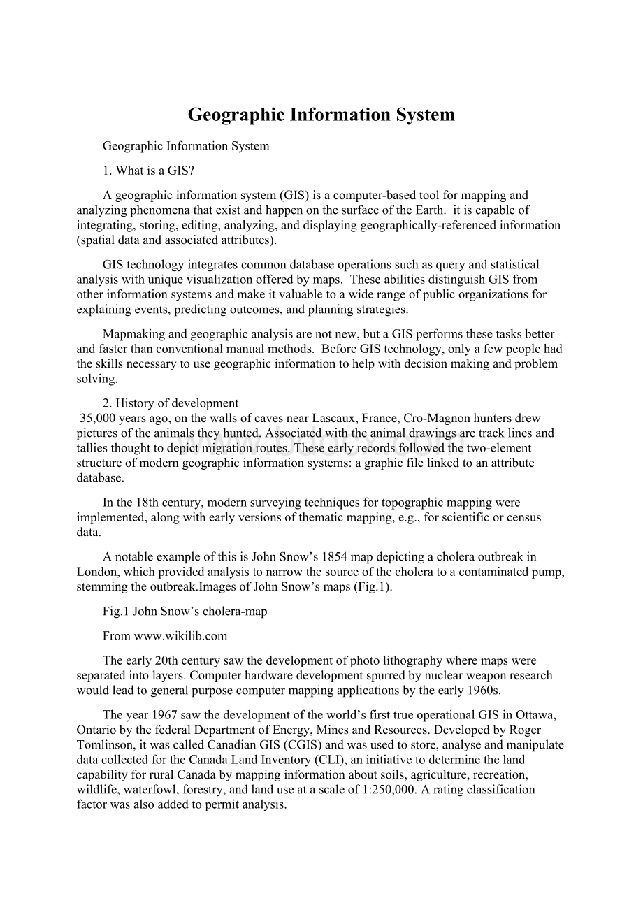
AnotableexampleofthisisJohnSnow’s1854mapdepictingacholeraoutbreakinLondon,whichprovidedanalysistonarrowthesourceofthecholeratoacontaminatedpump,stemmingtheoutbreak.ImagesofJohnSnow’smaps(Fig.1).
Fig.1JohnSnow’scholera-map
From
Theearly20thcenturysawthedevelopmentofphotolithographywheremapswereseparatedintolayers.Computerhardwaredevelopmentspurredbynuclearweaponresearchwouldleadtogeneralpurposecomputermappingapplicationsbytheearly1960s.
Theyear1967sawthedevelopmentoftheworld’sfirsttrueoperationalGISinOttawa,OntariobythefederalDepartmentofEnergy,MinesandResources.DevelopedbyRogerTomlinson,itwascalledCanadianGIS(CGIS)andwasusedtostore,analyseandmanipulatedatacollectedfortheCanadaLandInventory(CLI),aninitiativetodeterminethelandcapabilityforruralCanadabymappinginformationaboutsoils,agriculture,recreation,wildlife,waterfowl,forestry,andlanduseatascaleof1:
250,000.Aratingclassificationfactorwasalsoaddedtopermitanalysis.
CGISwastheworld’sfirstsystemandwasanimprovementovermappingapplicationsasitprovidedcapabilitiesforoverlay,measurement,digitizing/scanning,supportedanationalcoordinatesystemthatspannedthecontinent,codedlinesasarcshavingatrueembeddedtopology,anditstoredtheattributeandlocationalinformationinseparatefiles.Itsdeveloper,geographerRogerTomlinson,hasbecomeknownasthefatherofGIS.
CGISlastedintothe1990sandbuiltthelargestdigitallandresourcedatabaseinCanada.Itwasdevelopedasamainframebasedsysteminsupportoffederalandprovincialresourceplanningandmanagement.Itsstrengthwascontinent-wideanalysisofcomplexdatasets.TheCGISwasneveravailableinacommercialform.ItsinitialdevelopmentandsuccessstimulatedvariouscommercialmappingapplicationsbeingsoldbyvendorssuchasIntergraph.
Thedevelopmentofmicro-computerhardwarespurredvendorssuchasESRI,MapInfoandCARIStosuccessfullyincorporatemanyoftheCGISfeatures,combiningthefirstgenerationapproachtoseparationofspatialandattributeinformationwithasecondgenerationapproachtoorganizingattributedataintodatabasestructures.
The1980sand1990sindustrygrowthwerespurredonbythegrowinguseofGISonUnixworkstationsandthepersonalcomputer.Bytheendofthe20thcentury,therapidgrowthinvarioussystemshadbeenconsolidatedandstandardizedonrelativelyfewplatformsanduserswerebeginningtoexporttheconceptofviewingGISdataovertheInternet,requiringdataformatandtransferstandards.
3.WhatmakesupaGIS?
AworkingGISintegratesfivekeycomponents:
hardware,software,data,people,andmethods(Fig.2).
HardwareisthecomputeronwhichGISsoftwareprovidesthefunctionsandtoolsneededtostore,analyzeanddisplaygeographicinformation.
Geographicdata(layers)andrelatedtabulardataarenecessaryinordertoperformworkinaGISsoftware.
GIStechnologyisforlimitedvaluewithoutthepeoplewhomanagethesystemanddevelopplansforapplyingittoreal-worldproblems.
Fig.2GISkeycomponents
Lastly,asuccessfulGISoperatesaccordingtowell-designedplansandbusinessmethods,whicharethemodelsandoperatingpracticesuniquetoeachorganizati
 升级会员
升级会员 